bpm

Basic Instructions for Graphing Beach Profile Data

Note: only data that has been checked for accuracy and approved by program staff, will be made available for graphing. VISIT MGS COLLECTS: The beach profile graphing feature can be found at MGS Collects. Open MGS Collects in a separate screen, so you can continue to view the instructions below to navigate the system. SELECT […]

Read more
How to Interpret a Beach Profile Graph

Using the simple feature on MGS Collects, you can make a graph of beach profile data you select. But before graphing your data, here’s an overview of how to read and understand the graph. This is an example of what a graph looks like: THE PROFILE This graph of Ogunquit Beach in Ogunquit (OG), profile […]

Read more

Beach Profile Data

Since 1999, volunteers have been collecting profile monitoring data on their beaches once a month, 12 months per year. This data is submitted to an online database where it is first checked for accuracy, and then made available for use by researchers. Beach profile data is also available for viewing by the public, but before […]

Read more

Contact Beach Profile Monitoring Program

If you have questions regarding the Volunteer Beach Profile Monitoring Program, would like more information, or want to get involved, please contact us: Program Manager Jessica Brunacini Email Jessica Midcoast Office 14 Maine Street, Suite 304 Brunswick, Maine 04011 Volunteer Coordinator Brian Determan Wells National Estuarine Research Reserve Email Brian

Read more

Beach Profiling Data Uses

Beach Profile Data Informs Beach Management Beach profiling data is used to inform beach management decisions and to monitor the success of management programs. Here are some examples of how beach profile data has been used: Willard Beach, S. Portland: design of dune restoration and walkover/path improvements. Higgins Beach, Scarborough: evaluation of replacement seawall options. […]

Read more

Southern Maine Volunteer Beach Profile Monitoring Program

Volunteers Mapping the State of Maine’s Beaches since 1999 What is Beach Profiling? Beach profiling is a simple surveying technique used to measure changes in the contour of the monitored beach. The Southern Maine Volunteer Beach Profile Monitoring Program is a unique collaboration among local volunteers, participating municipalities, and scientists, resulting in over 20 years […]

Read more

Beach Profiling Volunteer Resources

Volunteer data managers, click here to enter data These resources are available for program volunteers as well as for public use and information regarding the program. Any group or individual interested in developing a profiling program at their local beach should first investigate access to and ownership of the beach as many locations are privately […]

Read more

About Volunteer Beach Profile Monitoring

Why profile beaches? Although sandy beaches represent only about one percent of Maine’s 3500-mile coastline, they are vitally important to the state’s economy as recreational resources, provide crucial wildlife habitat, and buffer the coast against storms. However, many of Maine’s beaches are threatened, mainly by erosion from coastal engineering and natural forces. Engineering structures, such as […]

Read more

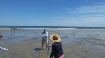
volunteers on the beach

The State of Maine’s Beaches Report

Scientists use Volunteer Data to Track Trends in Sand Movement at Maine Beaches The State of Maine’s Beaches is a biennial report produced by marine geologists at the Maine Geological Survey.  In the report, geologists discuss the significance of the volunteer beach profile data, including long term and seasonal trends, recovery of the beaches from […]

Read more