Experience the Rare Wonder of Maine’s Reversing Falls
Along the coast of Maine are places where, twice each day, rivers flow backwards and then forwards in an everchanging diorama of freshwater, saltwater, rollocking rapids and tranquil calms. These are the eight “tidal” or “reversing” falls, found where rivers and bays make a narrow passage to meet the sea.
These places are not many. In Harpswell, the open waters of Broad Sound flood into Potts Harbor at high tide, and then surge over ledges between Basin Point and Ash Point. The tides powered the George Trues Grist Mill in the nineteenth century; the remains of the dam enhance the reversing falls effect. Access is provided by the Town of Harpswell via Ash Point Road and Gristmill Road; a small parking area on the left has room for two vehicles.
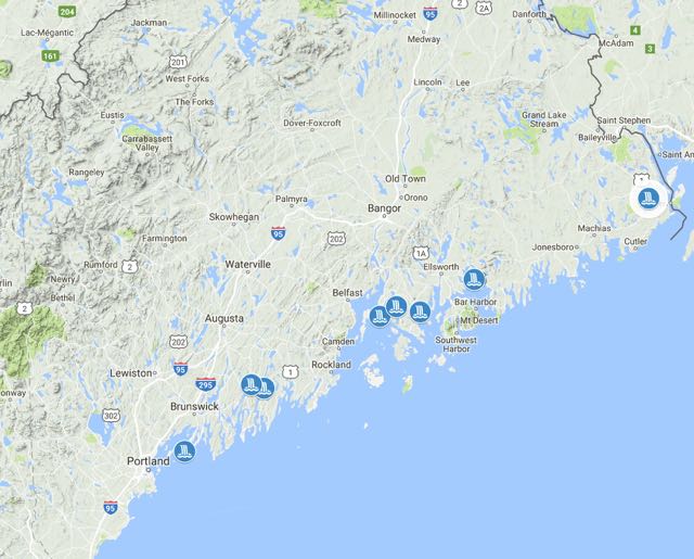
Two rivers reverse in the Midcoast region. At Sheepscot, nearly sixty miles of river, including Sheepscot, Turner, Long, Dyer, and Pleasant Ponds, join the Dyer River, the river nearly folding back on itself as it winds past Dyer Neck and through a narrow gap in a glacial esker before the river widens above Wiscasset. The falls are best viewed by boat from the water; there is no public access.
Easier viewing can be found less than seven miles east, where the Damariscotta River makes a similar twisting path around Glidden Point and beneath the Route 1A bridge between Newcastle and Damariscotta. Without a lot of freshwater flow, marine waters linger in the Damariscotta system, lending a name to Great Salt Bay and a greenish hue to the water. Here the falls are rarely slack, as high tide forces itself upstream, reversing the flow. Seabirds, schoolie stripers, and the occasional seal follow the tide inland, feeding on krill and other tiny creatures carried by the advancing saltwater. The tide turns; the flow reverses again as gravity’s influence resumes and the river flows south toward the Gulf of Maine. As the tide continues to drop, foaming rapids and standing waves emerge accompanied by the sound of rushing water. The birds disperse, only to return again at high tide, terns and laughing gulls hovering above the river, diving for food.
The next set of falls are on the east side of Penobscot Bay. On Cape Rosier, adjacent to Holbrook Island Wildlife Sanctuary, Goose Pond drains to the bay through a cleft in a bedrock outcrop in a chute of whitewater at low tide. High tide floods the falls, concealing all but the tops of the rocks and tufts of marsh grass as the water moves into the pond. The funky local geology, rich in minerals, led to a zinc and copper mining enterprise that contaminated the soil and groundwater of the cove, which is now a Superfund site.
The Bagaduce River falls are wide and dramatic. The southern arm of the river flows beneath the Route 175 bridge. Big waves at low tide swell into a reverse current on the high.
Blue Hill Falls form where the Salt Pond connects to Blue Hill Bay, a popular spot for kayak surfers.
Farther east, at Sullivan, tidal currents merging with Taunton Bay pass over obstructing ledges at the head of Sullivan Harbor, creating rapids at low tide. At high tide, giant blades of kelp and strands of rockweed spin and float in the fast-moving water. The current is constricted by Falls Point, a ridge of till and gravel on top of bedrock that marks an historic edge of the glacier, a place where the melting ice paused, and runoff piled gravel into a moraine at its feet.
Cobscook Falls can be viewed from Reversing Falls Park in Pembroke. In 1866, the Army Corps of Engineers removed rocks from between Falls Island and Mahar Point in an effort to improve navigation, but the tricky currents persisted, keeping out most fishermen and pleasure boaters. Water spirals and swirls as the tide rises and falls nearly twenty feet.
What makes a tidal fall?
Maine’s eight tidal falls, a relatively rare phenomenon, share certain characteristics: a confluence of fresh and salt water, bedrock ridges and ledges that constrict flow and force changes in water level. In the open ocean, the actual rise of the tide is only one to a few feet. But when a high tide moves into shallow water, against land and into confining channels, water “piles up” and the tide “rises.”
The tide moves up estuaries as an extended wave; where estuaries narrow into river channels, the tidal wave is narrowed and becomes higher as it moves upriver. The rising tide, floods too fast into too narrow an opening against the river’s current, sometimes creating falls or rapids on the upstream side.
The bedrock geology, channel width and depth have to be just right to produce a significant height difference on a rising or falling tide, according to David Brooks, an oceanographer from Maine currently at Texas A & M University.
Along the East Coast of the U.S., reversing falls are unique to Maine, a geologically young landscape still adjusting from the end of the last Ice Age 15,000 years ago. An ice sheet more than one mile thick prevented the formation of an extensive coastal plain like that found in the mid-Atlantic states. Drainage networks—the patterns of water flow and volume in coastal rivers and basins—formed as the glacier melted. Rivers tumble abruptly into the sea, confronting raw bedrock or glacially deposited gravel ridges (eskers and moraines).
Because of their constrictive nature and dynamic hydrology, tidal falls were popular locations for catching migratory fish like salmon and alewives. Tidal falls were also popular locations for building dams associated with water-powered lumber and grist mills during the period of European settlement. These human activities led to trails and roads being constructed across falls, with bridges sometimes enhancing the reversing effect.
The best way to experience the falls is to watch them as the tide rises or falls, spending enough time to see the currents shift and swirl, the water level change, and the coming and going of wildlife. Maine’s reversing falls offer a dynamic exchange of land and sea, the forces of the moon pushing and pulling against bedrock and glacial gravel, every day, twice a day, always.